 |
| Inclement weather |
We left out early from St. Cloud expecting a long day. We did not expect intense rain, and rain that lasted much of the morning. But it faired off after lunch and the rest of the day was gorgeous. The hills are a little more rolling but the agriculture is still predominantly soybeans and corn with the occasional field of sugar beets and sunflowers. As we headed into North Dakota, wheat and hay were added to the mix. As before, the fields are vast. In North Carolina, the roadside patches of wildflowers have been planted to reduce mowing costs. In North Dakota, sections of
 |
| Roadside harvest |
roadside are leased to farmers who harvest hay off of them--a boon to the farmers and the DOT.
We arrived in Bismark, ND mid afternoon really looking forward to NOT hustling up the road again for a few days. We are close now to the places we'd planned to visit and it finally feels like we are on vacation. As if to mark the occasion, Ruthie
 |
| Our current home, #52 |
pointed out the street sign in the RV park where we were to camp.
It was lovely to be leisurely. We ate a good supper, walked the park several times to get the cramps from sitting out of our legs, and we ended the day watching the pool robot wander aimlessly around the pool doing I'm not sure what. Ben talks about his daily pool maintenance routine at Millstone. I need to ask him about this.
 |
| Pool bot |
Our goal today was to explore Lewis and Clark's interactions with the Mandan Indians. As I have mentioned, Ruthie is the navigator here. I enjoyed an abridged audio version of Undaunted Courage about their expedition but was so dismayed with their intent to exploit the natural resources and their shabby treatment of the Indians I didn't retain much. It was an incredibly difficult trip and involved courage, ingenuity and determination but it was, in the end, greed-based and I have a hard time calling them heros. So I'm basically here to enjoy the scenery and I'm
 |
| Ft Lincoln memorial to the CCC |
 |
| Entrance to an Earthlodge |
leaving the history stuff to Ruthie. I was a little confused when she used the word Mandan in several different ways. So this is what I've learned: Mandan is a small town just outside Bismark; about 20 miles south of Bismark is a Mandan Village called On A Slant; thirty five miles north of Bismark is Fort Mandan (in Washburn, ND) where the explorers spent their first winter in a palisade fort, trading with other Mandan Indians and stocking up on food.
 |
| Mandan Earthlodges |
Today we were in all of them. And in Washburn, we also visited the Lewis and Clark Interpretive Center and saw a wonderful exhibit of paintings depicting Sakakawea (Sacagewea or one of many other spellings), but I'm getting ahead of myself.
We started out south of the town of Mandan visiting Fort Lincoln State Park. We were greeted at the entrance by a wonderful statue honoring the three million men who participated in the Civilian Conservation Corps. During
 |
| Inside an earthlodge |
the Depression, these men built many state and national parks and, because of their training and experience, were the first to enlist during World War II. Fort Lincoln is also home to a reconstructed Mandan village. On A Slant was so named because the village was on land that slanted towards the Missouri River. It was protected by a natural ravine, hand dug moat and palisade fence, and the river itself. At its peak it held 85 earthlodges. The earthlodges, built largely by women, were built on a frame of heavy timers overlayed with willow and thatch, then covered in dirt. The Mandan liked the white folks, were prolific farmers and enjoyed trading their surplus produce with the white trappers. Their territory was a good place for L&C to spend a winter acclimating to native interaction.
This village was on the decline due
 |
| On A Slant overlooking the river |
to smallpox when L&C were in the area so Fort Mandan is about 45 miles north, but you can see from the picture, its position overlooking the river was both lovely and secure.
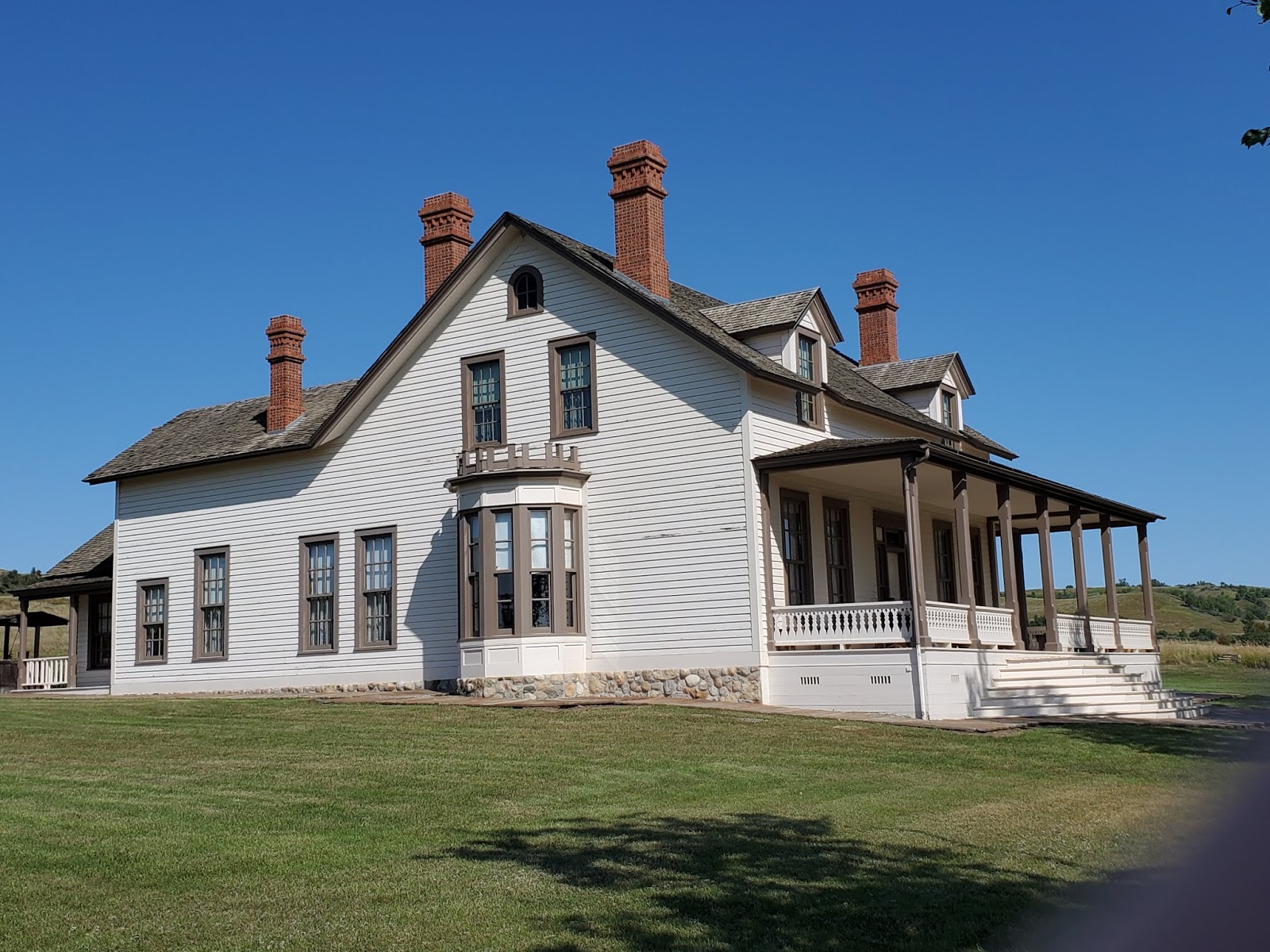
Seventy years later, Fort Lincoln was the last home of General George Custer. He left Fort Lincoln to arrive at Little Big Horn about 6 weeks
 |
| Custer's last home. |
later. His home (officer's housing) on the fort has been beautifully restored. The Interpreter, a local college student studying to be a social studies teacher, was full of information and recommendations for things to see up the road. Their gift shop and book store were pretty awesome as well.
 |
| Fort Lincoln Interpreter |
Our next stop was Washburn, ND for the Lewis & Clark Interpretive Center and Fort Mandan itself. We took a scenic backroad that frequently overlooked the Missouri River. We saw our first buttes. And we had a great lunch at a Dakota Farms restaurant that serves local meats and produce.
The land is open, we are in the prairie now. Lots of pasture and hay production, lots of wheat. It appears corn needs to be irrigated here, though we saw plenty along with soybeans. We saw lots of sunflowers here, cultivated in huge fields.
 |
| Buttes beyond the river |
Along the river, the hills are gentle but irregular and include the flat-topped or pointed "buttes" characteristic of the area--hills that rise abruptly, with steep slides. Trees are in the minority and cluster in protected areas among the hills or have been planted in deliberate windrows to protect buildings and crops. In the natural areas, it is grassland, and lots of it.
Once in Washburn, we started at the Lewis and Clark Interpretive Center with its
 |
| L&C Interpretive Center |
collection of artifacts and renderings of Sakakawea. Our day passes allowed us entry into the Fort Mandan historical site another 2 miles up the road. The fort was originally placed 10 miles up the river, but with flood control dams and time, the original site is underwater. Local historical groups lovingly recreated the original building on this site and filled it with period artifacts and reproduction costumes. There was a mile long walk along the river with informational signs about living conditions and natural history.
 |
| Dugout, tent and faithful dog |
We saw a dugout canoe like the ones L&C took up river to the river's mouth and we saw a wonderful statue of William Clark's Newfoundland dog, Seaman, who faithfully journeyed the 8000 miles they traveled and guarded Clark's tomb after he died. Most impressive was to
 |
| Fort Mandan |
see a period sextant and compass. Using sextant, compass and pocket watch, carefully wrapped in oilskins as they traveled, William Clark accurately surveyed the distance between St. Louis, MO and the Pacific Ocean--a distance of 3700 miles--within 40 miles. Amazing.
 |
| Sextant and compass |
I keep thinking about those oxcarts we read about at a rest stop in Iowa that traveled 15 miles a day through mud and insects (the Interstate now follows their path), and the 33 men who left Fort Mandan to paddle up the river and a couple of thousand miles west to the coast. It took them 18 months to travel from St. Louis to the Pacific so I guess I should quit fussing about long days at the wheel. It is a VERY big country and we are only seeing a small portion and in a short period of time. But what we are seeing is beautiful and the immense work of the farmers
 |
| Seaman memorial |
leaves me grateful. Tomorrow we visit the Knife River where L&C met Sakakawea, the wife of a fur trader, who knew the Indian languages and helped negotiate their safe passage. Then on to Montana. Westward Ho!


Outstanding report! I can see it, the many shades of Mandan. Glad you put in a good word for the CCC. And the dog, awwwwww...<3 Happy Trails for sure.
ReplyDelete