Friday, August 30, 2019

Lewis and Clark Overland--Part 2

Lolo Pass from the Visitors Center
While Lolo Pass, in the Bitterroot Mountains, is lower than Lemhi Pass at about 5300 feet, it was the more treacherous. For L&C, that is. We had paved road, a nice visitors center and friendly rangers to answer questions. We approched Lolo Pass from the Traveler's Rest State Park, the site where the Corps of Discovery set up camp before crossing the pass.

At the Traveler's Rest Interpretive Center, we saw replica tipis used by the Indians and replica tents used by the Corps. Clearly the Indians had the advantage. Before leaving on this trip, Jessie sent me an article she'd found
Plains Indian tipi
about how the L&C campsites were identified by archeologists. Apparently mercury was a common medicine and their latrines were full of it. Such was the case at Traveler's Rest. Since it took them a while to identify the exact spot, lots of history had happened since the Corps camped there. It was interesting to see the area protected by the state park jammed up against local development.

A few miles up the road was the visitors center for Lolo Pass. We could have driven a mile down a dirt road to get to the actual campsite but the lovely ranger station, hot coffee, fun gifts and helpful ranger sidetracked us. This clearly was the much more visitor-centered
US Military tents

experience than Lemhi, if not quite so true to the Corps' experience.

The Bitterroot Mountains were much steeper and more heavily wooded and yet now more developed than Lemhi. We saw these wonderful rock formations near a hot springs that had been a resort in times past. We passed this charming public school, small ranches and housing developments.
Lolo Pass Visitors Center

So here we leave Lewis and Clark to complete their mission as we head south and east to complete ours. From here on out, we leave the past and enjoy the present--pure vacation!

Next report from Cody, WY. We pass through the Absaroka Mountains.
Wonder if I'll get to meet Walt Longmire...


Lolo Hot Springs


More Lolo Hot Springs


Rural MT Public School with cattle guard

Lewis and Clark Overland--Part 1

Mountains near Elk Bend, Idaho
For two nights, we are camped at Elk Bend, right on the Salmon River. We are somewhat isolated, 21 miles to gas in Salmon, but right across the street from an excellent pub and food. Our goal was to traverse the two mountain passages that L&C had to cross to reach the Snake River and resume their trip by water. This is the last leg of the L&C trip for us. Tomorrow we cross to Cody, WY, then south to Santa Fe, then east towards our lovely, green Appalachian Mountains and sweet Uwharries. We are currently under a weather alert for possible fires. It is windy and incredibly dry.
The approaching Rockies

L&C were able to follow the Jefferson River a bit past its confluence with the Missouri, but the mountains blocked their way. They had either to find horses to cross the mountains and find another river flowing west or return east having failed in their mission to reach the Pacific and map a trade route. Their success depended upon local tribes. They approached Lemhi Pass, which
Salmon ID on the way to Lemhi
crosses the Continental Divide when they were met by local Shoshone Indians. Their chief happened to be Sakakawea's brother who welcomed her return and provided horses and a guide across the Lemhi Pass and on through the more difficult Lolo Pass across the Bitterroot Mountains and on to the Snake, then Columbia Rivers. Sakakwea, with her interpretive skills and connections, gets much less credit than she deserves for saving the mission and securing the United State's claim to the land. #TooTypical.

Ruthie and I did this a little backwards. We drove past the difficult Lolo Pass yesterday and explored Lemhi today. Lolo Pass was on a
Crossing the 45th Parallel
comfortably paved road. Lemhi Pass was accessible via a 36 mile loop of primitive, one lane road, sans guardrails and with limited markings. Both passes, however, offered spectacular views of wilderness not unlike what met the Corps of Discovery.

I've ordered the pictures as L&C would have seen them. Today, navigating Lemhi Pass, was the one occasion L&C might actually of traveled faster than we did.

To get to the Lemhi Pass road, we had to go through Salmon, ID, our last chance to get gas and talk with a ranger about road conditions. Nineteen miles south of Salmon, at a little crossroad named Tendoy, the road begins. Half way between Salmon and Tendoy, we also crossed the 45th Parallel, half way between the Equator and the North Pole. Who knew?
Tendoy Business District

Maintained by both the Forest Service and Bureau of Land Management, the road is challenging, especially an 8 mile stretch called Agency Creek Road which is restricted to vehicles with good ground clearance and good tires. I used 4WD low to good effect coming down twisting 20% grades and was grateful to the guy who designed rear view mirrors that fold against the car every time I met another truck on the road. To their credit, the government agencies did provide an occasional vault toilet on the route, fully handicap accessible, tho we never could figure out why.

Lemhi Pass

Much of what we saw at Lemhi seemed barren but under Forest Service and BLM management, recreation, ranching and timbering occur and we saw evidence of all of them. But mostly we saw huge expanses of wilderness and tall mountains up to Lemhi Pass on the Continental Divide at 7373 feet.

As I mentioned, the road was spectacular but nerve-testing. In the last
What lay ahead across the pass
stretch we crossed a number of cattle guards (and drove some cattle off the road). All across Montana and Idaho we noticed these unusual rail fences. Ruthie presumes that they are both easier to build--no digging post holes in rocky ground--and more resistant to the press of heavy animals.


A great drive, if you can get to it.

Road to Lemhi Pass
  
Road to Lemhi Pass
  

Where are the guard rails?!
  
Rail fence
  
Crossing a cattle guard, leaving Lemhi
And on to part 2...


Wednesday, August 28, 2019

River's end

Gates of the Mountains
While we have been "following" the trail of Lewis and Clark, we haven't been. L&C traveled the Missouri River based on hugely inaccurate maps that indicated that the Missouri went all the way to the Pacific coast, or at least crossed paths with a river that did.  We, of course, have been on roads that roughly follow the Missouri, but it is a totally different experience. And the river itself is different with numerous flood control dams predated by a history of floods that have changed the riverbed. Also, the same early map guiding L&C totally failed to mention the Rocky Mountains and other important details. The mission of the Corps of Discovery was to find an economical passage to the Pacific and locate a trade route. In that day, navigable rivers would be that route and mountains were a significant barrier.

As Ruthie and I have been crossing the Missouri, it has been getting smaller. I'm
Vertical ridges at Gates
sure this concerned the Corps of Discovery and it should have. Near Helena MT, the river passes through a deep gorge. Ancient limestone ridges rise vertically from the water and at one bend, an optical illusion makes it look like they form a gate that blocks the river. As you round the bend, the "gates" open to reveal a passage. We took a boat ride into the gorge--that is now 20 feet deeper due to flood control dams--and tried to imagine how they saw it. You can visit the Wikipedia page on Gates of the Mountains and see a series of photos that show the gates opening.

The tour guide was generous with his storytelling and often funny, until we reached Mann Gultch where, in 1949, 13 firefighters died in a horrific firestorm. Their
Effects of healthy fire
story was painful to hear and their deaths haunted both the survivors and this community. There were fresh scars left by recent wildfires. At one point he showed us a gultch that had experienced a "healthy fire"--one that takes out weak trees and underbrush to open the canopy to new life. That said, the other side of the mountain had been devastated.

While I am sure the Corps was relieved to find that the gates opened the river for them to travel a bit further by water, they struggled to find ground flat enough in the gorge to camp. There is only one lovely picnic site in the current wilderness area, and a couple of  very small camp sites with no services that are approachable only by boat. A few years back, wildfires destroyed the underbrush holding the soil on the cliffs above the picnic area and the forest service has had to literally dig out the campground several years running. It has only recently been reopened. The Corps of Discovery had paddled their entire route upstream. Imagine them worried and fatigued and unable to find a suitable place to camp. Eventually
Headwaters of the Missouri
they did and continued on, but within another 90 miles, they had reached the headwaters of the Missouri River with no suitable waterway to carry them further. We visited that confluence today.

So the Missouri River is the longest river in the US, longer than the Mississippi into which it flows. Together they make the 4th largest river basin in the world. L&C hoped it would carry them northwest towards the Oregon River which sailors had mapped on the west coast. But the river turned sharply south at Great Falls and ended where three rivers empty into it. Lewis named the three rivers after the men who sponsored them: Galatin, Jefferson and Madison. All three rivers are smaller than the Missouri and head the wrong direction, as in not across the major mountain range ahead of them.  At this point, the Corps stashed their boats and buried much of their supplies and hoped to find the Shoshone Indians to whom Sakakawea was related in the hopes of buying horses to cross the mountains. Tracing those steps will be our adventure tomorrow and Saturday. At that point, we will head south and eventually home.

Effects of irrigation
Which brings me to the subject of home. When I visited New Brunswick earlier this summer, I was immediately struck with the sense that I could happily live there. I have had no such feeling for this place. I've enjoyed the beauty and appreciated the history, but it is not my green Appalachians and I am ready for them again. This picture shows the effects of irrigation. Basically what is green is irrigated. The last KOA we stayed in had miles of dripline crisscrossing the campground to keep their windbreak trees alive. This one has a sprinkler system that runs at night to keep our few shade trees going. I know the locals love their home, and I love mine. Looking forward to leaving L&C to the rest of their adventure and
finding my way home.

Our one last great discovery of the day was the Wheat Montana Deli and Bakery. Connected to a major flour mill, it was doing a land office business in lunches and the biggest dang cinnamon rolls I have ever seen (or eaten, which we did in stages...). Now that was something to write home about.

Monday, August 26, 2019

Walk in beauty, better yet, drive...

The words for today are Glacier. National. Park. See below (click on the pictures to enlarge):
Our first mesa

The Rockies from a distance

Glacier National Park

Glacier National Park
Glacier Park St. Mary Lake
Glacier National Park
Jackson Glacier

Glacier National Park


Ruthie at Glacier
 
1936 Tour Bus- "Refurbished by Ford, Powered by Propane"


Lake McDonald Lodge

Lake McDonald Lodge

Lake McDonald Lodge
  
Lake McDonald
  
Welcome to Blackfeet Reservation
   
Blackfeet Reservation
  
Roxy Theater, Choteau MT
   
Massive farm machines everywhere!
   
Safely home


Sunday, August 25, 2019

Damn dams and waterfalls

I will start off with a bit of humor courtesy of Barb Swanson who is in Iowa as presidential hopefuls descend. We are in high spirits ourselves having landed safely in Great Falls and with 110 power working (no GFI breakers!).

Apparently the confluences of unmapped rivers with the Missouri posed problems for the Corps of Discovery. Sometimes it was hard to tell which was the correct channel. Today they pose opportunities for the Corps of Engineers. We've talked about the confluence of the Missouri and Yellowstone Rivers at Fort Union. For the
Fort Peck spillway has 16 gates
past two nights, we've camped at the base of the largest hydraulically made earthen dam in the world holding back the fifth largest man made lake in the US. Made me just a taste nervous... That said, the Fort Peck Dam is an engineering marvel. The dam is 4 miles long. To avoid erosion, the spillway is three miles away. There are four tunnels over a mile long that divert water to the far side of the dam. Two tunnels power turbines, two simply drain water so that the spillway is only needed in
Spillway downstream
emergencies, though they have been in regular use due to heavy rain and melting snowpack. Over 40 men were killed building the thing, some whose bodies were never recovered when a portion of the dam failed during construction. The dam was built as a WPA project during the Depression. 10,000 men and women first had to build a town, railroad line and power lines into the middle of nowhere and then build, what was at the time, the world's largest dam.

The Fort Peck Dam has two powerhouses, one built in 1940 and another added in 1961. They are tall because the facade covers up two enormous tanks that act as surge protectors. If the turbines have to be turned off quickly, water diverted to them needs a place to go.
Fort Peck Powerhouses

As I mentioned, this place is in the middle of nowhere. Everything had to be brought in or built on the spot. Much of the original town is lost but a few buildings remain, including this recreation hall that now serves the town as a theater and city admin building.

Fort Peck Recreation Hall
Lake Peck itself is primarily a fishing lake. We saw campers everywhere who had come for the purpose of fishing. The state operated boat launch had fish cleaning stations and there were two marinas to accommodate their boats.

Back in L&C's time, the big problem was whether to take the "milky" river branch or the clear one. The Milk River empties into the Missouri at this
point, and again, our intrepid adventurers discerned the right path and continued up the Missouri.
Panorama Fort Peck Lake and spillway

Our intrepid selves headed off to Great Falls via Loma, MT to another place L&C had to take on a river confluence. On the way, we got our first glimpse of the Rockies rising on the horizon. We drove through an Indian Reservation and found this abandoned mission church with a
Distant Rockies
Abandoned Mission
graveyard full of cheerful, recently placed flowers. And Ruthie had to safely navigate through a blinding rain with wind gusts that nearly ran us off the road as a front came through. We dodged our first tumbleweed during the storm and later saw a prong horned antelope and mule deer enjoying freshly mowed fields. We also saw something we'd never seen before--power poles made from laminated wood instead of whole trees. They tended to be used at corners, when the lines turned. Seemed like a cool idea.

Laminate light pole


We also caught a great shot of a train rolling past a small town grain elevator. EVERY town we passed through had these old timber elevators covered in metal like my grandfather's, except they were much larger than the ones back home. I'm amazed they have survived. Most appeared to be still in use.
Old grain elevators


Like the old cotton mills in North Carolina, they tell the history of the Montana economy in each town.

We also had lunch near this statue of James J. Hill, Empire Builder and founder of the Great Northern Railway whose tracks we frequently followed.
James J. Hill

Loma, MT is at the confluence of the Missouri and the Marias Rivers. Once L&C figured out which was the Missouri, Lewis named the other river for his cousin Maria--Maria's River. We've had this discussion about improper punctuation regarding Hungry Mother State Park (as in Hungry, Mother). With time, the apostrophe got dropped, clouding the meaning of the river's name. The story goes that L&C asked the men to vote on which branch of the river to take. One branch was muddy, the other clear and cold. The men thought the muddy branch was the main branch. L&C decided to take the clear and cold one. Again, they made the right choice. Despite the disagreement, the
Sign at Decision Point
men followed faithfully and the mission continued. The Forest Service has named the area Decision Point and has created a trail with more of those interpretive signs to tell the story.

Decision Point


At this point, everything in Montana feels isolated, even this historic site. The actual confluence of the rivers is green and gorgeous but this picture of Libraryann in the parking lot conveys just how desolate a feel the rest of the area creates. We skipped the early parts of the L&C trail where it passes through highly developed areas in favor of visiting areas they retain the flavor of what the Corps of Discovery saw. I can't imagine how they felt in
Where Maria's River meets the Missouri
a place so far and so foreign from their lush Virginia.

Note this picture of the town of Loma from Decision Point. There are four grain elevators. Not a single church. The abandoned mission may have been the only church we saw today. We are clearly not in the South...

Loma from Decision Point
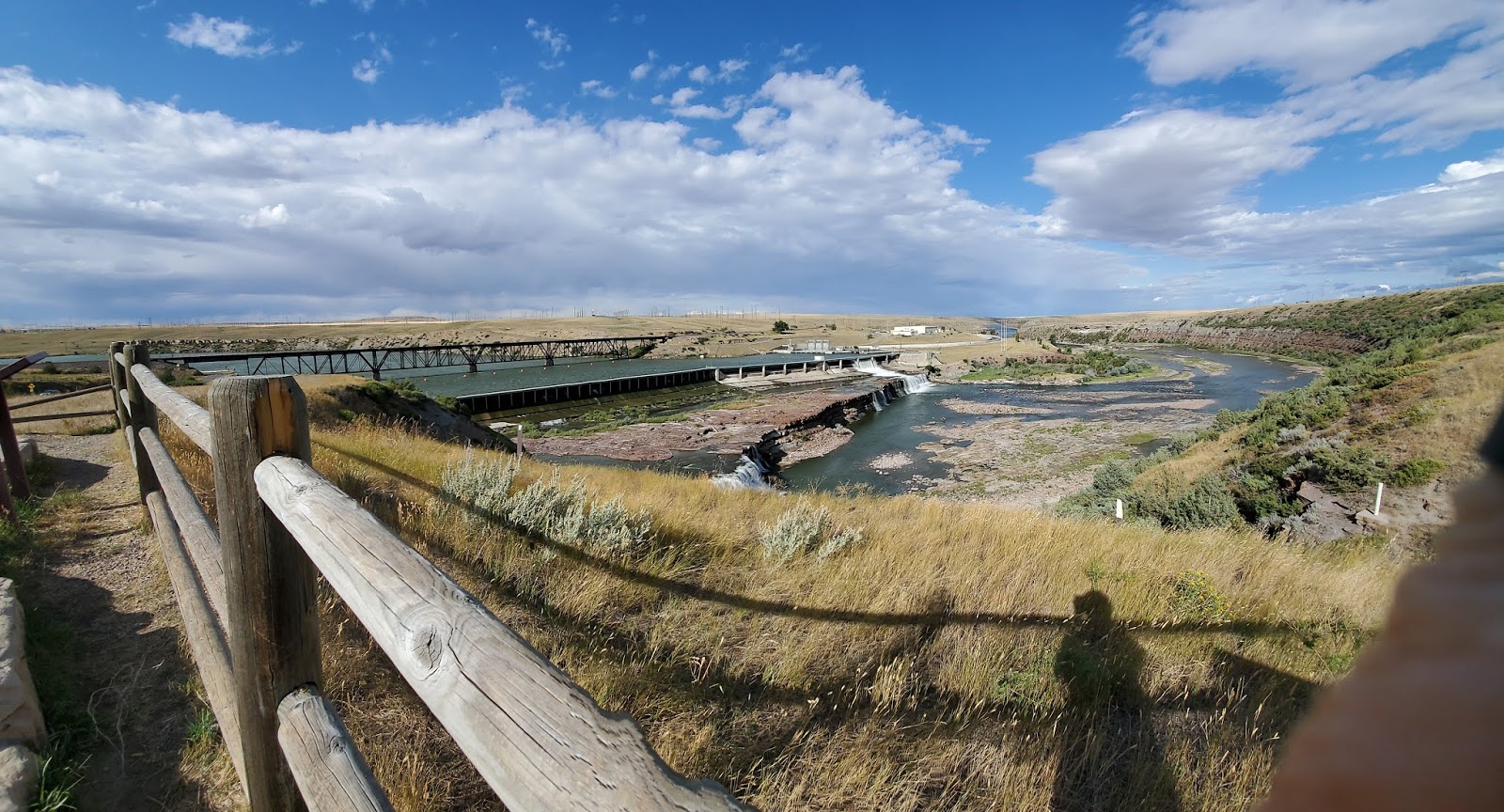
We finally made it to our KOA in Great Falls, so called because there are 5 major
waterfalls in a 12 mile stretch of the Missouri River. The problem for L&C was how to get around them. The answer was to build carts out of Cottonwood trees and portage 18 miles to a place where they could safely re-enter the river upstream. They had four heavy dugouts and made the trip four times. Historians
Panorama Rainbow Falls
consider it their greatest challenge. The Corps of Engineers has turned four of the five falls into locations for hydroelectric dams. The fifth set of falls is often underwater from the downstream impoundment. I took a panorama of the Rainbow Falls dam that includes a railroad trestle bridge built for James J. Hill's railroad. He brought the trestles for the bridge in from Ohio in 1901. They are still in use.
Pictures of the dugouts are from the Lewis and Clark Interpretive Center at Rainbow Falls.

We are headed out to Glacier National Park tomorrow early, hoping to beat the crowds. Stay tuned!