Sunday, September 2, 2018

And another scenic river valley--Retirement Trip Day 12

Three bridge abutments at Grand Falls
Ben and I are getting a little tired of traveling and all that the added burden of camping entails with set objectives and breaking camp almost daily. We both woke up sluggish and grouchy and not really wanting to hit the road again. Until we did. Then it was all ooohs and aaahs and look at that!

We tried to view the gorge at Grand Falls last night but the rain was awful. So we decided to try one more time. The entrance to the public overlook is in the parking lot for a zipline that crosses the gorge. Some folks is crazy. That said, the parking lot was empty in the early morning and we headed for the overlook. The welder was excited to see bridge abutments for all three of the bridges that have spanned the gorge. The public overlook is built on the
Hydroelectric Dam at Grand Falls Gorge
pilings of the first bridge. He got even more excited to see the history of the bridges posted as we walked in. I got excited to see that there was a tall cage around the cantilevered observation deck. The gorge is 280 feet deep in spots. Did I mention I do not like heights? Still, it was lovely, but we both were glad to trot off the cantilevered deck once we snapped some pictures.

Yesterday, we were driving back roads up the St John River Valley on a provincial scenic byway. Today we completed the byway and crossed the border into Quebec, and back to our standard time zone about 10:30am. Vita had directed us to a scenic back road along the mighty St Lawrence river as we headed southwest towards Quebec City. We were gobsmacked. To the left of us were towering folds of granite, to the right, the broad St Lawrence. Between them was wonderfully fertile farmland dotted with huge barns, comfortable farm houses and sweet villages.

When we were in New Brunswick, we were charmed by the clapboard churches, largely Protestant and surprisingly, largely Baptist. But we were in French Canada now, and each village hosted a towering cathedral. The river valley is very flat and we could see church spires long before we could see the villages. Again, the road was narrow and getting off to take pictures was a challenge, but we captured a few.
St Lawrence River

We are in Plessisville now, scheduled to visit the folks who made my Weaverbird loom early tomorrow. We did make a trip in to town to be sure we could find the place, especially since we will be towing tomorrow. What we found was lots of road construction in tight downtown places and lots of one way streets. We have now identified a route that avoids most of the mess and are ready to tuck ourselves in for a chilly 50 degree night. We are also ready to come home. Lots of folks here speak no English and the bilingual signs are a thing of the past. We really are foreigners here and I'm surprised that I find no excitement in it. Probably because it's the end of the trip and we're sort of played out of excitement. I'm just ready for some familiar.

You can click on each photo to enlarge it and enjoy these beautiful village churches.


Godde willing, we will be back on US soil tomorrow night.


Wednesday, August 29, 2018

Scenic River Valley--Retirement Trip Day 11

Grand Lake ends in the St John River. The St John River Valley is credited with being the most scenic river valley in all of Canada. New Brunswick has identified a number of scenic routes and between their map and clear signage, we had no trouble enjoying the trip.

The river is broad and the road follows along close by through primarily rural areas and occasional small villages. We saw lots of lovely old farm houses typified by the steep central gable seen in these two charmers.
 They remind me of the old houses with a "Carolina A" back home though most of the houses we saw did not have a front porch. Obviously the steep pitch of the A is a nod to winter snow but they seem to be about the same age as the Carolina As, early to mid 1800s. We also saw many charming clapboard churches replete with gingerbread details and of a wide variety of denominations. As detailed as the woodwork on the churches was, the farmhouses were surprisingly plain by comparison. Very little gingerbread, very few with shutters. Still, they all had their own charming flavor.

Anglican Church
We did see a lot of water damage at the start of our trip up the valley--many homes with siding replaced several feet up from their foundations. Vita said 13,000 homes had been damaged. In an area so sparsely populated, it indicates the expanse of the flood.

Anglican Church
We saw these beautifully preserved clapboard churches the entire length of today's drive. It was hard to stop for pictures on the narrow road but we caught this Anglican Church at a wide place and managed a picture of these two across the river through the windshield.

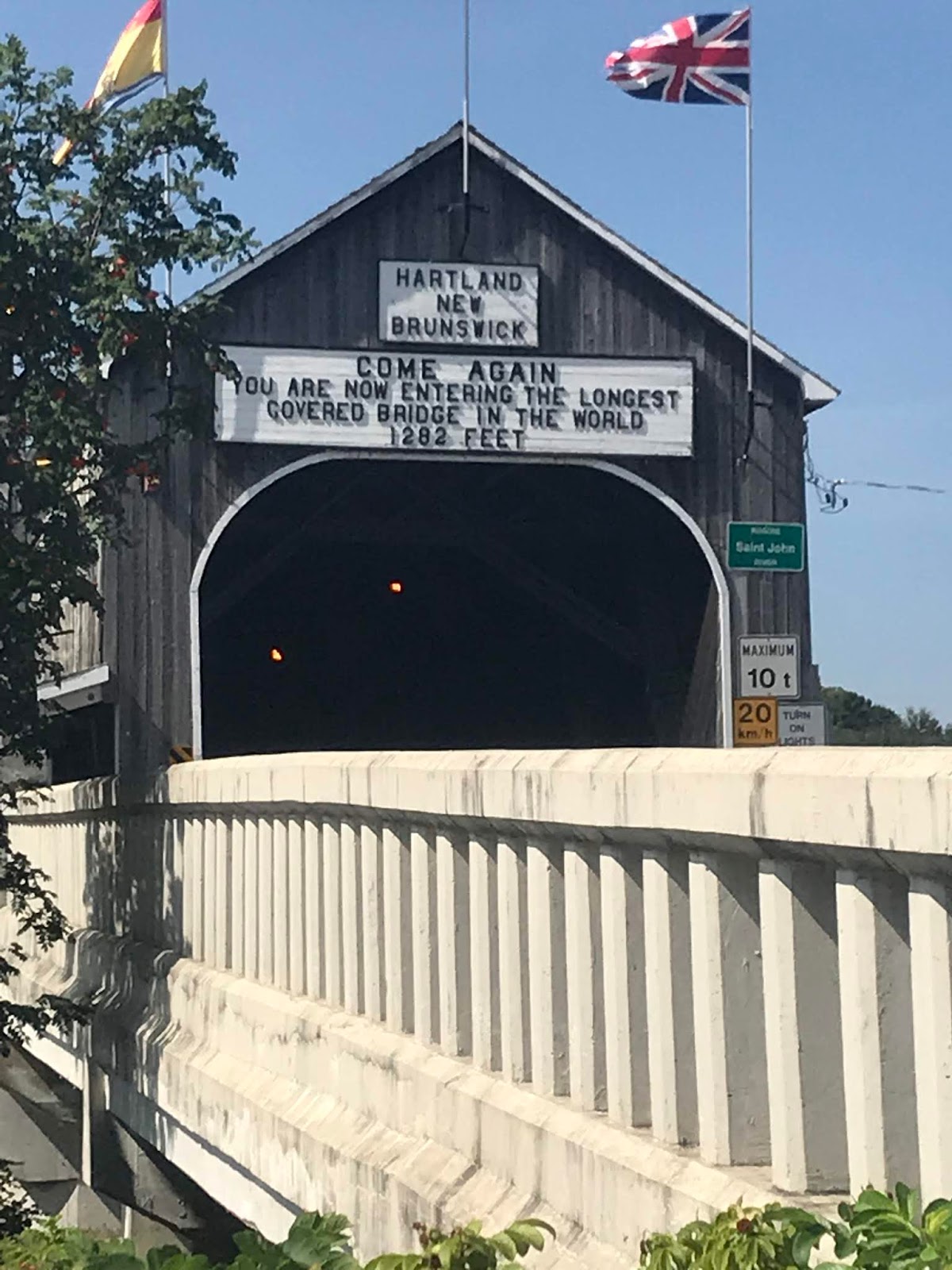
We also saw the world's longest covered bridge. It was being repaired, so we couldn't drive a cross, but it was impressive. The Canadians love their covered bridges and build them with aplomb. A cross country bicyclist stopped in a gift shop we were visiting and asked the clerk what he should see in town. She mentioned the covered bridge and he replied that he'd seen the world's second largest covered bridge already in Quebec. We passed others on the way including one bridge that had a covered section to the first abutment followed by trestles the rest of the way across the river. In fact, we saw many graceful and intriguing bridges of all sorts. Ben the welder enjoyed them all and photographed most of them. 
World's Longest Covered Bridge
Yet another lovely bridge
And, of course, we had to stop at a train exhibit--The Smogonoc Train Museum--such wonderful names. And finally, we are in Grand Falls. We have yet to see the falls. It has started to rain, but not hard. We may take a trek into town for supper and see what we can find...
Smogonoc Depot


To the house of a friend, the road is never long--Retirement Trip Day 10

The old Danish proverb proved true.

Ben and I packed up the trailer, had a lovely walk around Lake Lily and through the arboretum and then had a leisurely lunch at the cafe overlooking the lake. My friend, Vita, had planned to meet us after lunch and drive us to her house. Plans changed when long awaited contractors appeared out of the blue, so with a couple of phone calls to clarify the route, we headed to her home in Jemseg.

There are a lot of trees in New Brunswick. Miles. We drove through them an hour and a half almost without seeing a structure. And as they say, it was just the tip of the forest.

Vita was a professor at NC State when I met her. I was privileged to take her Jacquard weaving class.
Grand Lake from Vita's Living Room
When she and her husband returned to their lovely home on Grand Lake, we stayed in touch. A return to weaving has been on my heart for some time and was a big motivator in my choice to retire. I was hoping to find some inspiration in speaking with her and I was not disappointed.

Vita & Ben at play
Shy Luka
Their home overlooks Grand Lake. The lake is 32 miles long and capable of extraordinary weather. This spring, they were inundated with rain and faced floodwaters 12 feet higher than normal. It threatened the foundation of their home. When we arrived, they were working to raise and extend an existing stone barricade and also installing a higher barricade behind it. With the help of friends, they had moved an enormous amount of rock into wire cages that act as a filter to let the floodwaters move through  yet retain the soil. She also talked about hurricane force winds and water spouts that took out trees and damaged property around them. When I say they were working on the barricades, I mean that Vita and her husband, John, were placing the rocks--into two barricades 65' long, about 3' wide and 3-4' tall--themselves. So I think they were just a little glad to take a break.

We were also thrilled to see Luka, their Standard Poodle who attended our barn raising back in 2009. While he wouldn't pose for the camera, he was as friendly and handsome as ever.

After catching up on the news, Vita wanted to show us the village of Gagetown and a community project dear to her heart. There has been a tradition of tartan weaving in Gagetown. The Loomcrofters house is a 1761 British munitions building that has been moved and repurposed several times. It houses several looms and a cache of yarns. As the town's weavers have died off, Vita is teaching local students the craft. We enjoyed several of the town's historic buildings including the 1835 courthouse and the home of one of the Fathers of the Canadian Federation.
Courthouse

The Tilley Home--A Father of the Confederation


Village of Gagetown
After the tour, she and John fixed us a lovely supper and we chatted into the evening. As if reviving the friendship weren't enough, she has me feeling ready to weave again and I am grateful.

Monday, August 27, 2018

Slap Dang Nuthin'--Retirement Trip Day 9

What we did today was slap dang nuthin'. I worked on yesterday's blog post and finished my Margaret Maron mystery and that was about it. We were both whupped from all our many adventures and decided to take a time out.

Our campground is in Rockwood Park, designed by the same architect as New York's Central Park and the second largest city park in Canada. There is a lake with a pavilion and restaurant near the campground entrance and we finally roused ourselves to have a lakeside supper there. I have included the napkin holder in the picture which describes how the restaurant is non-profit and benefits the park.

Outside the pavilion is this sundial sculpture which reads, "Honor the dead, fight for the living" in honor and memory of all the workers injured or killed at work building the nation. I could not help but think of Greg and wonder where his memorial is. There's a lot to like about Canada.

Ben is building a campfire. I intend to enjoy a non-alcoholic beer and head to bed. Starting to feel like vacation. I could live like this...

Big Changes--Retirement Trip Day 8

After a leisurely start to the day--we left out about 11am, this was our first view of the Bay of Fundy at Fundy National Park. We broke out a picnic lunch in the lovely seaport of Alma, just east of the park at full high tide, about 1:30pm. We came back around low tide that evening for a wonderful supper of fish and chips. I have pictures below that dramatize the changes in this largest of the world tide. According to brochure notes, boats can only enter and leave this harbor at the high tides and you can see why.
Alma at 1:30pm

There is also a lovely little beach at Alma (at high tide--it was a quarter mile deep at low tide!) where Ben enjoyed skipping the flat, tide-worn rocks that make up the beach. It has been a special pleasure to be able to spend time with him this way. Both my children are adults now and as their responsibilities increase, their time with me diminishes, as it should. But watching Ben enjoy the ocean brought back a flood of memories. As a toddler, he had few words. His dad and I took him and his sister to Murrell's Inlet for their first view of the ocean. Greg kneeled down beside him in the sand and said, "It's the ocean, Ben. Big, ain't it?"

After a long silence, Ben furrowed his brow and said solemnly, "Big."  He was 11 when his father was killed. Shortly after we were at Jordan Lake and I saw smooth stones on the ground around us and grieved that his father would not be there to skip stones with him. I think it was the first realization of how big my job would be. So I tried my best to show him and we spent some time slinging rocks into the water. I'm happy to say there have been enough good men in his life, he's gotten
a little better instruction at it and does quite well. That said, it feels good to be making new memories with him now and I hope for the opportunity to do more of this with Jessie.

View from the bridge
Our travels after lunch took us to explore the charming park gift shop (did I say carmel maple popcorn??) and then a trip out to and across the Wolf Point Covered Bridge. While this bridge is in the park, there are apparently many well preserved and still in use covered bridges throughout New Brunswick and the highway department has thoughtfully put signs up to indicate their location. We passed by several getting here but this is the first one we crossed. Beautifully preserved, it spans a river just at the point it enters the bay. Later, we walked through dark, deep woods to near the water's edge and sat on a bench taking in the ocean through fir trees and talking about dreams and plans.

NB Railway Museum
After Wolf Point, we headed up NB 114 through Alma to the town of Hillsborough to check out their train museum. The museum is small, short of funds and volunteers, but Ben saw items there he'd only read about and had a good talk with an older gentleman who had volunteered there for some time. They discussed old equipment I had no clue about and pleasantly connected in the way men do comparing notes on tools, cars, trains and other common interests.

We decided to take a different way home and stopped for gas on the way. In Canada, gas is priced by the liter and in pennies. ie we paid 125.6 per liter, or about $3.60 per gallon. Receipts are not itemized here so I'm not sure how sales tax runs. So far, my credit card works just fine and I leave it to them to do the math. That said, NB has lots of scenic highways, for which we have a map, and we decided to amble home a little closer to the coast than NB 114 was taking us. Main roads in NB seem to be in very good shape, but the secondary roads, the further away from main roads, become increasingly rough. Nothing quite matched what we experienced in Maine, but weather is clearly a factor here and I don't envy the job of the DOT.

Cape Enrage
Low tide near Cape Enrage
We did enjoy some spectacular views. We decided to take a short side trip to a place on the map labeled Cape Enrage. When we arrived, we discovered that it was a tourist spot requiring admission and we were not planning to stay long enough to justify the expense so we took a couple of pictures and headed on towards Alma and supper. The Cape Enrage lighthouse is short and sturdy, and low tide at the base of the cliff is dramatic. There is a zipline from a rocky outcrop above the lighthouse to just at its base. I'm sure it gives you the feel of flying out into the bay, something some of the road curves did without the price of admission.

We had supper at the Alma Boathouse--traditional fish and chips for us both and Ben sampled local beer. It was 10pm when we got home and midnight before we hit the hay after tidying up the camper. We have seen so much, we are both on overload. I think tomorrow will be a day of rest.

Saturday, August 25, 2018

O Canada--Retirement Trip Day 7

I tried to post last night as I usually do before bed but despite promises that my Verizon Plan is in full effect in Canada, traffic on the local tower was so heavy I was unable to upload pictures. I am now in the camp laundry room with excellent FREE wifi--not even a bounce page login required. O Canada!

Algonquin Lodge St Andrews By The Sea NB
We left out about 8a and headed up US 1 towards St Stephens New Brunswick (Calais, Maine across the river) to go through the border crossing gates. US 1 runs through Sanford, NC, near where Greg grew up and I am regularly there for paddle club meetings and to visit Greg's family. It was fun to see the same brownstone rocks as in Lee County and pass through Jonesboro, ME and recollect Jonesboro, NC adjacent to Sanford. But it was NOT nice to drive long stretches of US 1 with absolutely wretched pavement, and for a couple of miles under repair, no pavement at all. I realize the Maniacs have to deal with weather extremes, but at times I was forced to drive in an otherwise 50 mph zone at a crawl to avoid beating my equipment to death. So no pictures here. Of course, Canada 1 with the same extreme weather was beautifully paved.

That said, we crossed the border (after waiting on background checks--why can't potential employers be this fast!?!) in about 15 minutes, a blissfully fast passing for a camper after having heard horror stories on the RV forums. Our first stop was the lovely resort town of St Andrews By The Sea on Passamaquaddy Bay. We pulled off at a public park for lunch and as we pulled out of town, drove through the arch of this incredible lodge.

Our next stop was at an Information Station (aka rest stop and welcome center) outside Saint John. While much of the driving is very similar to driving in the US, there are some differences. Because they  acknowledge that they are a multilingual nation, they rely a lot on international pictograms on their signs--hence the big question mark. The images make total sense once your autopilot adapts to them but there is an adjustment period. My truck speedometer does mark kph but in tiny, hard to read numbers below the mph. Fortunately, my gps translates both speed and distance into the more familiar miles. I really don't want a speeding ticket! And their traffic signals are smaller and not bright yellow as at home. I really am having trouble with that and nearly ran one. Ben is a big help!

Between the nerve-jangling roads in Maine, uncertainty about the border crossing, and adjusting to the subtle difference in driving here, and having pushed really hard these past seven days, we were exhausted. We took naps. Very long hot showers, fixed a lovely meal over the grill and hit a local grocery to resupply. While Ben fixed supper, I enjoyed my Margaret Maron mystery in the laundry room washing clothes. After our grocery run, we hit the hay early and have lingered over this morning #8.

We have some mysteries of Canada yet to uncover--like why these buses are pink and why all the plumbing fixtures look like 1980 and why you can buy wine in the grocery but ONLY non-alcoholic beer (which they have in wonderful variety). And why can't the US still have Superman phone booths? I am sure we will discover more. One item that is not a mystery is why everyone we chat with asks how it is we endure the current political situation, but that is another concern for another time.


Our campsite is atop a hill and part of a major downtown park with a restaurant, multiple lakes and over 50 miles of walking trails. We appear to be in the industrial district with heavy road traffic and perched high above a rail classification yard, which pleases Ben to no end. This pic, from over the fence behind our spot shows the expanse of this part of the city. You can see refinery towers in the distant left. The following picture shows last night's lovely full moon with the refinery exhaust fires burning beneath it.

We are taking it easy again today, puttering off to Fundy National Park. Will report in as technology
allows...

Friday, August 24, 2018

Winter Harbor, Bar Harbor and Cadillac Mountain--Retirement Trip Day 6

Winter Harbor Library Historic Room
Winter Harbor Public Library
Winter Harbor Library Circ Desk
The plan was to take it easy today, poke around Bar Harbor and take the afternoon off to rest. That was the plan, but there's this really friendly Park Ranger who actually grew up in Lenoir and who keeps giving us great suggestions. The first and best place she sent us today was the Winter Harbor Public Library. Winter Harbor is the little town at the exit from the Schoodic Loop drive through the National Park. Their library is in a lovely old chapel. It's only open two days a week and Friday was Storytime. As we were leaving, mothers with small children were hurrying up the walk. Libraries are sacred spaces to begin with but the remarkable setting makes this one doubly special.

Rockefeller Building
Our next stop was the Schoodic Education and Research Center. In 1935, just prior to WWII, JD Rockefeller talked the Navy into moving one of their secret listening posts so he could build a public road into the National Park. The Navy used this extraordinary Tudor building to house officers--yet another remnant of coastal fortifications that have been converted to historic/recreational sites.

The wood on the facade is local cypress and is all hand-pegged. The lintels are trimmed in copper. The stone and brick are beautifully crafted. The building is hardly standard government issue. Apparently Rockefeller built the building for the Navy to sweeten the pot when he asked them to move. The Navy occupied the building until 2002 and in 2006, a local philanthropist donated money to restore it for use as a welcome center.

Charming Bar Harbor...
...with a taste of Gatlinburg
Whoopie Pie
From here we drove from Schoodic Peninsula to Mt. Desert Island which contains more of Acadia National Park and the lovely town of Bar Harbor. Even though we were camping, we tried to doll up just a taste. I had heard that Bar Harbor was an elegant resort and I was worried about feeling out of place. When we got there, parking was nearly impossible. We finally found a spot near a high school ball field on the edge of town. When we finally made it downtown, we discovered a wonderful charming New England town with a taste of Gatlinburg thrown in. We were not out of place at all and had a great time poking around in the shops and searching for just the right lunch spot. I can't do shellfish but Ben had a lobster roll and we both sampled local desserts. Ben's choice was a Whoopie Pie--even more than he could eat. So far, most of the folks seem very athletic and outdoorsy. The town was full of outfitters and both kayaking and rock climbing seem to be popular. But Maniacs also love their pastries and ice cream. We saw bakeries and ice cream shops everywhere. I want to know their secret for keeping the bakers in business and not looking like it.

There is a scenic loop through the Mt Desert Island section of the park and we drove it culminating in a trip to the top of Cadillac Mountain. Apparently, Acadia National Park preserves the tallest rocky banks along the US Atlantic seaboard. Cadillac Mountain, the tallest among them, stands 500 feet taller than the highest peak in our ancient Uwharries back home. You can see from the map I posted a few days ago, they are all part of the Appalachian chain. Driving this loop, we had the eerie feeling we were driving the mountains of home but right on the edge of the Atlantic Ocean. Below are a few of the pictures we took.
Mountains of Mt Desert Island

At low tide

From the top of Cadillac Mountain
We made it home in time to fix a lovely steak dinner on the grill. We took one last picture of a blood red full moon rising above our campsite. The camera in my phone does not capture the color but maybe you can feel the peace.